Call Us: 866.481.7333
Blog
Contact Us
Dealer Login
  • Products
    • Soybeans
      • P3 Soybeans
      • PFS Soybeans
      • Seed Treatment
    • Corn
    • IP Soybeans
    • Wheat
    • Yellow Peas
  • Promise+
    • Financing
    • Rewards
  • Our Difference
    • Quality
    • Research
  • Find a Rep
  • About Us
    • The Ag Team
    • History
    • Careers
  • Become a Partner
  • Products
    • Corn
    • Soybeans
      • P3 Soybeans
      • PFS Soybeans
      • Seed Treatment
    • Wheat
    • IP Soybeans
  • Promise+
    • Rewards
    • Financing
  • Our Difference
  • Find a Rep
  • About Us
    • The Ag Team
    • History
    • Careers
  • Become a Partner
  • Blog
  • Contact Us
  • Dealer Login

Integrate UAV Technology with Yield Maps

Published by Nolan Berg on December 3, 2015
Categories
  • Technology
Tags
  • dakota farmer
  • UAV

UAVs have been front and center on the agricultural stage over the last couple of years. Is this new technology just fun and games or a valuable tool for farmers?

For as long as agriculture has existed, farmers have gathered data. How do we merge our historical data with the new technologies of UAVs to make us more efficient and profitable farmers?

Georeferenced yield map data has been around since the early 1990’s but for most farmers, these yield maps have been used as refrigerator pictures rather than useful tools to drive decision making. In order to utilize data, it must be compiled in some sort of management software that provides an organized way to store and analyze it. By examining multiple years of yield maps, we can create zones reflecting areas of consistently lower or higher than average yield, allowing unique management of each zone to maximize yields and minimize inputs.

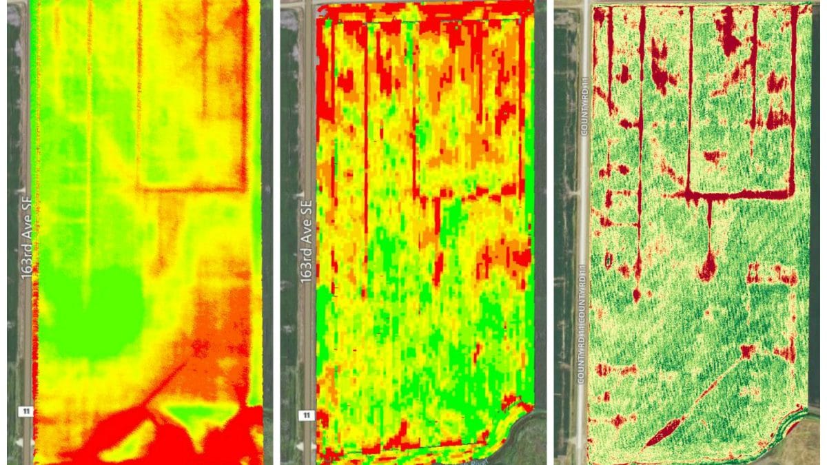
Adding layers of information to a yield map can help identify reasons for the highs and lows and provide insight on how to manage these zones. I believe a topographic map (shown on the left in the image below) is a layer that shows one of the most valuable pieces of the equation. Gravity is always trying to move water down. Water follows the path of least resistance, which is usually the topography of your soils. Depending on the amount and timing of moisture in the growing season, yield maps and topographic maps relate to each other fairly strongly.

Aerial imagery is another vital part of identifying and understanding the zones of a field. Satellite imagery is a great way to get historical views of a field. Publicly available satellite images have been around since the late 1980s and can be used to build an aerial history of a field. When analyzing aerial imagery, straight lines typically are manmade while irregular shapes can usually be attributed to a natural cause.

We know yield maps can provide insight to help create zones within a field. But, yield maps are only available yearly and depending on crop rotation, comparable yield maps may only be available every two to four years. What if you could see multiple “yield maps” per growing season? Imagery from UAVs can do just that. When placed side by side, the yield map generated on October 15 (center image) looks nearly identical to UAV imagery gathered on July 9 (image on right).

side by side

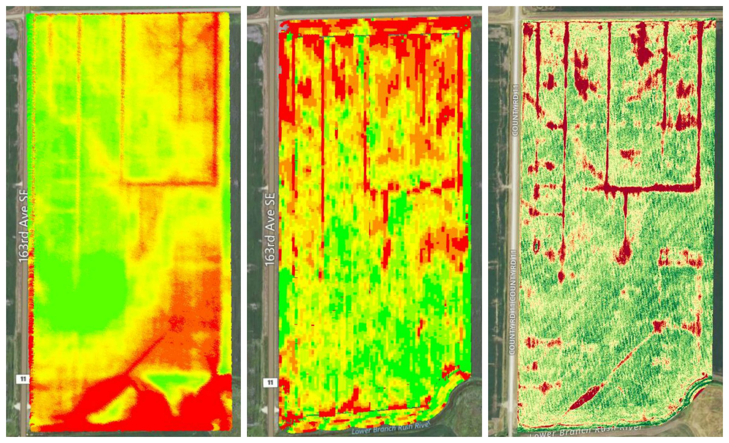
Topographic map (left) / Yield map (center) / UAV imagery (right)

Analysis software determined that these images are similar, and have a very strong correlation of 0.73. For example, two identical images have a correlation of 1.0. The more differences between a set of images, the closer the correlation is to 0. This proves that UAV technology is an excellent addition to topographic and yield maps that farmers already utilize. UAVs provide in-season data, giving farmers a better understanding of the growing season at hand. It also means that utilizing UAV imagery provides more opportunity to act during the season to manage specific areas of a field. Management could range from adding nitrogen to areas that have been denitrified or leached, spot spraying weed patches, or even replanting areas of the field.

UAVs provide much more than a picture of your fields. The farmer who uses fewer inputs and achieves greater outputs comes out ahead. Being efficient with inputs such as fertilizer, pesticides, and tillage also has environmental benefits.

Having access to UAV imagery throughout the growing season will prove to be an effective tool with endless uses.


Share
Nolan Berg
Nolan Berg
If you say “jump”, Nolan Berg won’t just ask “how high”… he’ll show you. Nolan pole vaulted for NDSU’s track team (his personal best is 16’ 2”), and his drive and determination carry over into his ever-evolving position as Precision Systems Agronomist. With a master’s degree in Plant Sciences and tenure as track team captain, Nolan is a great fit to lead our precision ag activities, work with zone creation and UAV imagery, and assist with the seed increase program for new genetics. In his downtime, Nolan enjoys hunting, mountain biking, running, and photography. He lives in Fargo with his wife, Melissa and dog, Basil.

Related posts

March 24, 2022

Massive Strides in Drone Technology Prove it to be an Everyday Tool 


Read more
March 17, 2022

Singulation: How Much Will 95% Cost You?


Read more
January 14, 2022

Split Applied Nitrogen in a Drought


Read more

Subscribe to Swenson’s Snapshot Weekly GDU Report!

First Name

*

Last Name

*

Email

*

Search Our Blog

✕

Categories

  • Agronomy
  • News
  • Ole & Sven
  • Peterson Community
  • Research & Testing
  • Seed Genetics & Traits
  • Technology

Browse Archives

December 2023
M T W T F S S
 123
45678910
11121314151617
18192021222324
25262728293031
« Aug    

Peterson Farms Seed

3104 164th Ave. SE
Harwood, ND 58042

Toll Free: 866.481.7333

Products & Resources

Corn
Soybeans
Find a Rep
Dealer Login

Keep in Touch

© 2020 Peterson Farms Seed. All Rights Reserved.